The 826.16 Acres
The 826.16 Acres is a bit of a different situation from Sections 1, 2, and 3.
First, the numbered sections were explicitly granted the easement rights by the developers in deed records from 1958 and 1959. There is no such document for the 826 acres.
Second, a Title History search refers to the documents for sections 1, 2, and 3, but does not record an easement for the benefit of any other area.
Third, unlike Sections 1, 2, and 3, which are well documented, including maps, the records of the 826 acres are not as easy to determine.
In 1968 and 1969, there were some shenannigans which led to the ALERC v Gilliam trial:
The trial court “recognized the existence of a perpetual easement for ingress and egress in Lot No. 4 to the waters of Lake Austin in favor of the lot owners in the Austin Lake Estates subdivision and the present and future owners of lots sub-divided out of the original 862.16 acre tract adjoining that subdivision”
In the appeal, the trial court’s findings were affirmed.
Unfortunately, neither the trial court record , nor the appellate court record , nor the 1969 Quitclaim Deed (referenced in the lawsuit) gave a description or map of the 826 acres.
However, the 1959 deed from Duffy to ALE does describe the property (pertenant part below):
862.16 acres of land, more or less, 38.45 acres being all of that tract out of the Tyler Tap Railroad Company Survey 140 patented to J. F. Clark, 77.0 acres a portion of the Thomas Bird Survey 81, about 145.01 acres being a portion of the H. S. Whitehead Survey 943, about 41.0 acres being a portion of the T. J. Robinson Survey 942, 10.1 acres being all of the S. Gorman Survey and about 550.60 acres being a portion of the Robert Harvey Survey all in Travis County, Texas, and being a part of these tracts of land as described in a deed from E. B. Calvin, et ux, to Chas. A. Duffy as recorded in Book 816, Page 161, Travis County Deed Records , as prepared for Austin Lake Estates by the Metcalfe Engineering Company, 1710 Eva Street, Austin, Texas.
Much of the remainder of the document catalogs old metes & bounds information, including markers such as a cedar stump that had a nail in it in 1915. This is not very helpful, but fortunately this old WCID 18 map shows all of those original old survey locations:
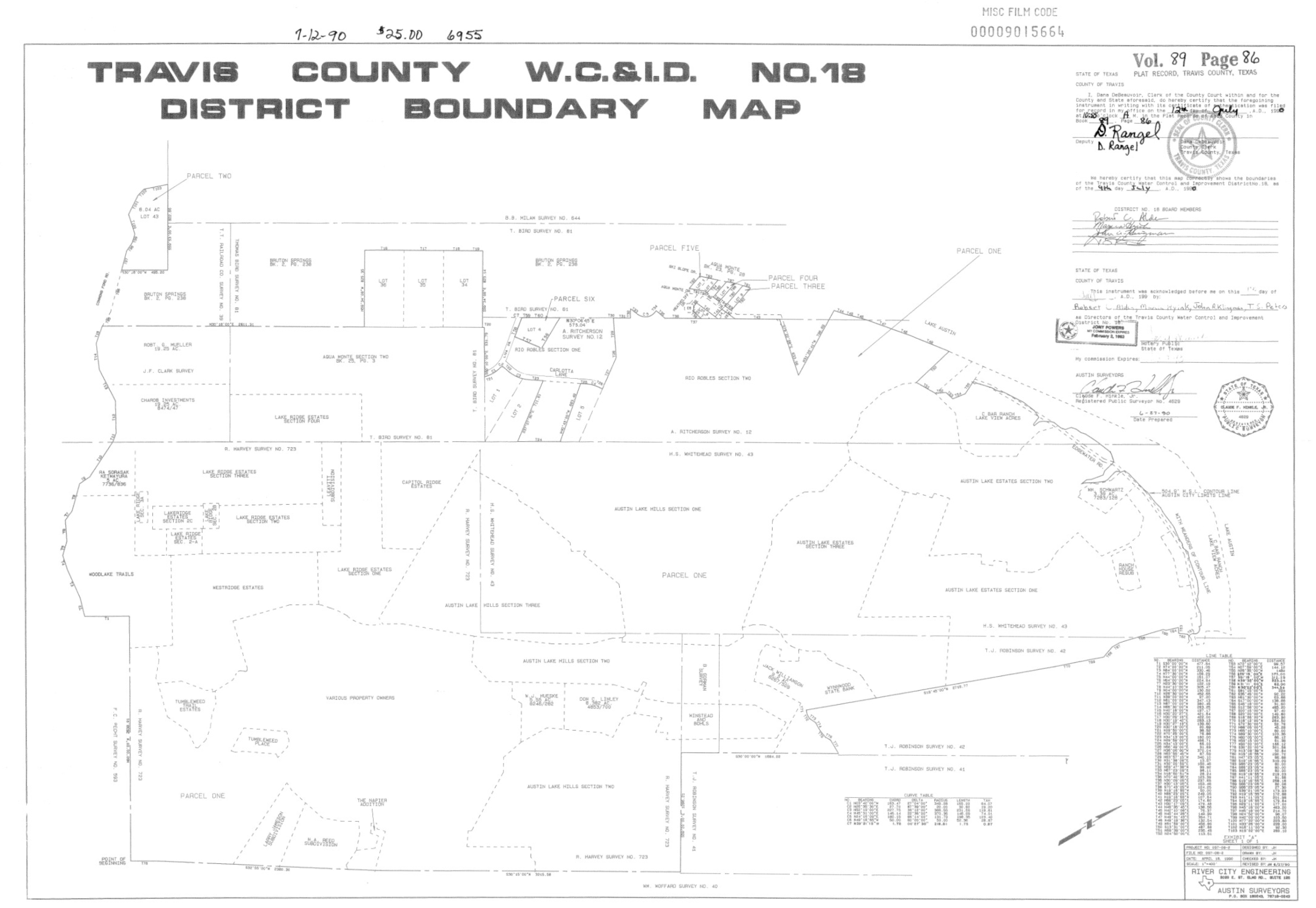
From which we can derive the following map:
NOTE: Most of the property lines in our neighborhood were drawn along survey lines, but there is at least one home that has a minority portion of the property in an original survey, with the bulk of it outside. The example I’m aware of is 10212 Birdlip Circle - a portion of this property is in the Tyler Tap #40 Survey, and thus the Association has generally treated such property as being subject to the deeded access rights.